 |
|||||
|
|
|
|||||
|
|
|
|
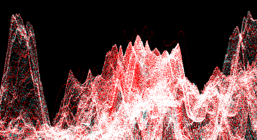
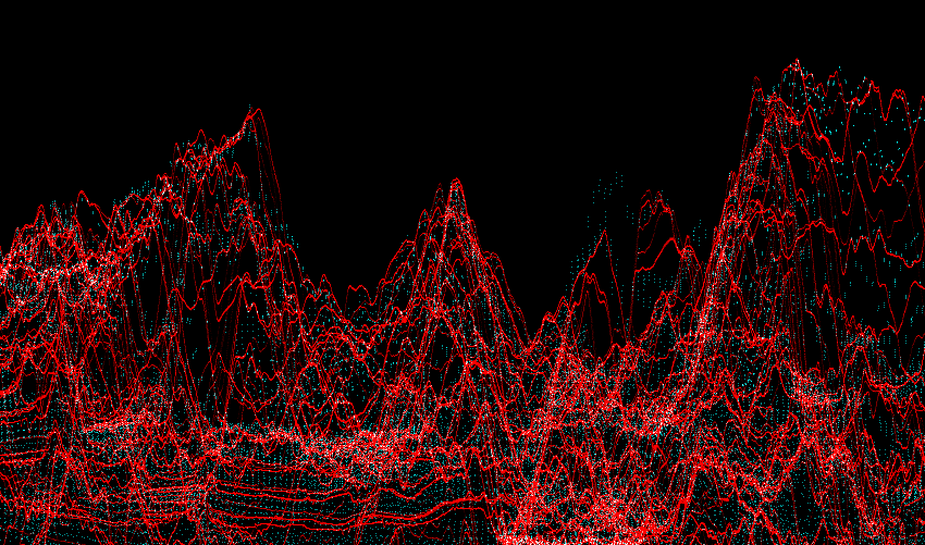
Lunar Reconnaissance Orbiter data for Limb ProfilesOne of the biggest uncertainties in eclipse predictions is the actual profile of the Moon: mountains, craters, and valleys. Eclipse chasers have been waiting decades for improved knowledge of the shape of the Moon, and readily incorporated JAXA's Kaguya data, revolutionizing the accuracy of eclipse contact time calculations. NASA's Lunar Reconnaissance Orbiter carries a very accurate altimeter, the LOLA, which has been mapping the Moon for months now. Now, LRO's LOLA promises to literally fill in the gaps left by Kaguya. When LRO's first set of data was released on March 15, 2010, we instantly set to work downloading the 90+ GB of RDR data and processing it. It became quickly apparent that the data was of very good quality once filtered for obvious problems. After discarding unusable data points and ones that were nowhere near the Lunar limb as seen from Earth, we were left with about 434 million data points. (For the technically minded: we AND'd the SHOT_FLAG parameter with 0xFCFF to determine when to kick a data point, tossed out data points showing more than 4km/second of elevation change, and then removed data points lying under 60 degrees of latitude and longitude.) Stripping out unneeded metadata left us with a more manageable 3.2GB data file. Because the data was essentially the same format as Kaguya, it plugged right into the processing routines developed for Kaguya and a 6MB limb profile data file for Eclipse Orchestrator was generated easily, although it took a while: 29 hours using 8 CPUs. Upon comparison of the LRO and Kaguya data sets, they show very consistent results, with some obvious data errors. Take this view of the polar region, with the vertical axis stretched greatly to show small differences. LRO data is shown in red, Kaguya in blue-green. LRO data appears as a solid line because of how many more measurements it takes. The correspondence of the data sets is striking. However both Kaguya and LRO show bad data points. We ended up searching for these sorts of problems manually in plots such as this, and then removing them by hand (avoid lro_no_01/lolardr_092681542.dat and lro_no_02/lolardr_093121035.dat).
At the equatorial regions of the Moon, the across track resolution of LRO is comparable to Kaguya and each spacecraft missed mountains here and there. Below, where the blue dots rise above the red, Kaguya saw a mountain that LRO missed, and vice versa for red traces above blue. For this reason, we carefully merged the LRO and Kaguya datasets for Eclipse Orchestrator, to provide the most accurate and comprehensive data available. Some of these missed mountains cause up to about 0.5 second of change in eclipse contact times for the 2010 total solar eclipse.
Every quarter until the mission ends, new LRO LOLA data will be published, improving the cross track spacing and catching the last of any missed mountains. We plan to update the data file used by Eclipse Orchestrator regularly to incorporate the latest available data. |
![]()
All text and images are © 2008-2020 Moonglow Technologies - All Rights Reserved.